About
The application of contemporary photogrammetry technologies in the construction industry is gaining momentum. As a result, we see these technologies popping up in various processes: ranging from 360 photography and video recording to advanced scanning technology using infrared and LiDAR technology. We have divided the devices used for this purpose into two categories: scanning equipment using a tripod, and drones with an internal camera.
Based on the input obtained during the focus committee meetings, in this practice-oriented project we wanted to respond to the needs at hand and, partly as a result of this, worked towards a multidisciplinary set-up of the spearhead project Photogrammetry in Construction. The findings of our research, as well as of the case studies carried out, provide a future-oriented starting point for the further elaboration of the obtained photogrammetric scans and how to use them for accurate measurements. The intended accuracy is of the measurements is an important aspect, but here it can be assumed that the focus on high accuracy does not always favour feasibility in the adoption of photogrammetric techniques for organisations. This hands-on project will answer the question of realistic, feasible measurement methods that are readily applicable and financially viable within enterprises. Especially for organisations that want to deploy photogrammetry but are still searching in terms of implementing this technology, these measurement methods will be able to generate added value. Not only direct benefits the technology can offer will be outlined, but also how photogrammetry relates to current developments in immersive technologies such as Augmented Reality and Virtual Reality.
Research Project
During this project, we met with various parties and attended demonstrations and lectures. The focus committee meeting also gave further direction towards a multidisciplinary approach. The following emerged from these questionnaires and discussions:
- Mobile and affordable fixed scanners are found most useful
- Augmented & Virtual Reality is considered both extremely useful and not useful
- Future outlook is positive, possibilities are increasing
- Technology is becoming more widely applicable
- There is conservatism in the industry
- The drive for ever higher accuracy is not always effective for implementing photogrammetric applications
Opportunities emerging strongly from the focusgroup:
- LiDAR Scanner
- Usable model after scan
- Infrared
- Measurement
- Automated processing
- Market study
- Facility management applications
- Smartphone applications
Drones Scans
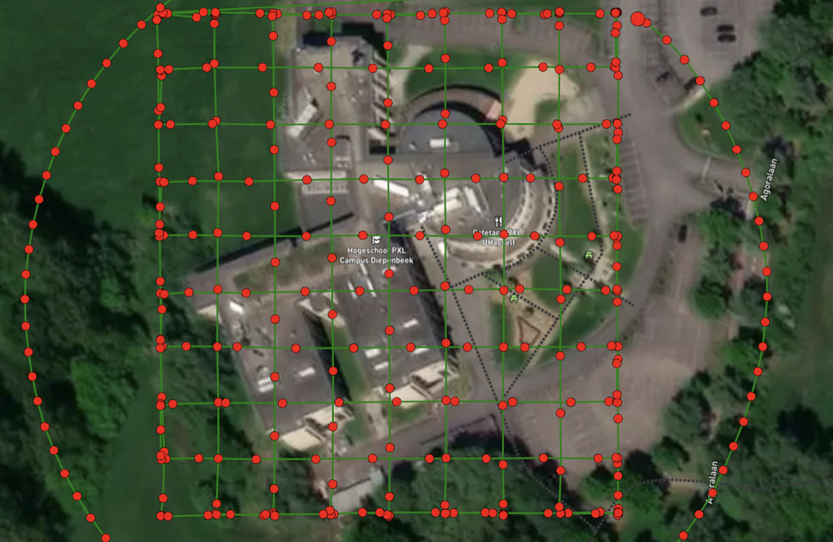
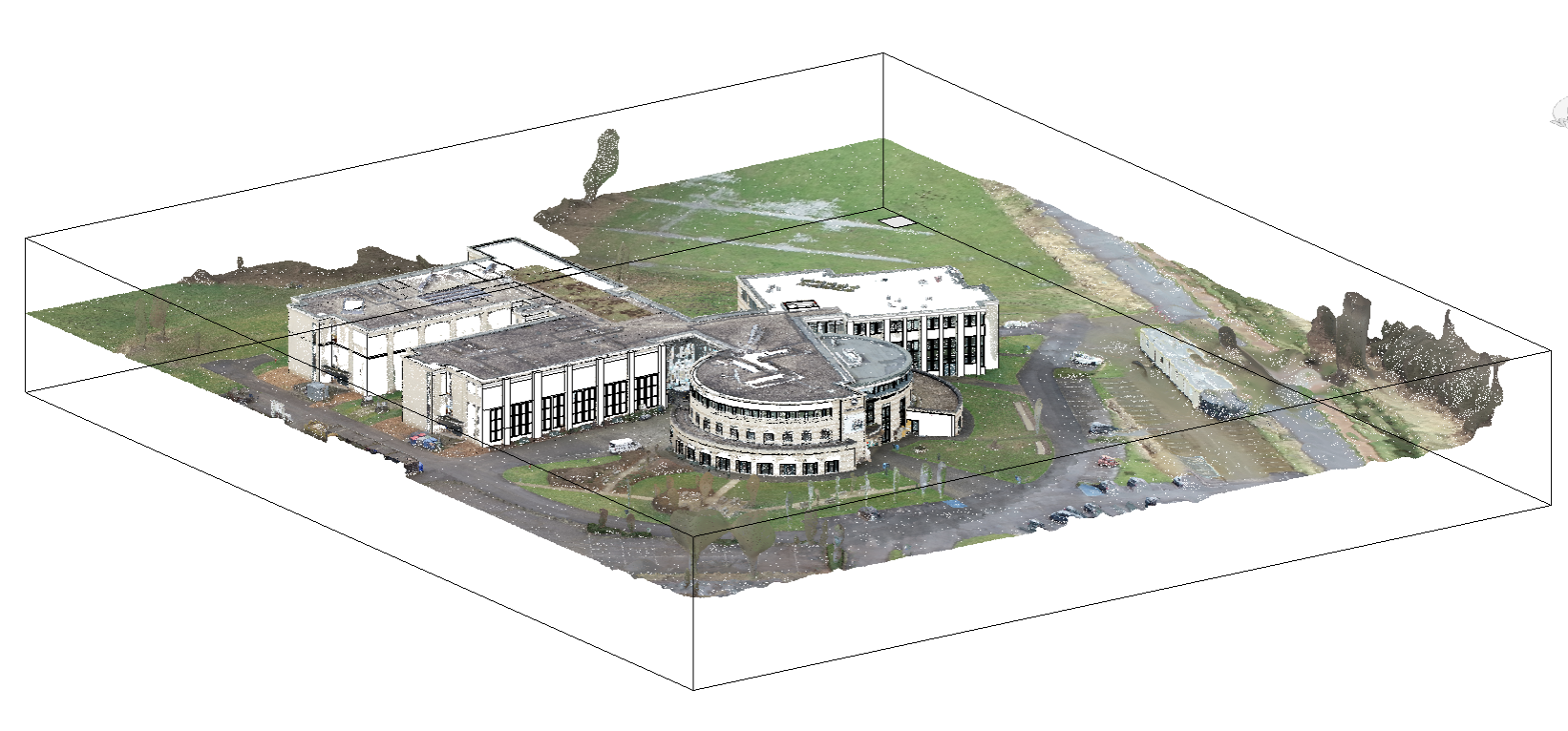
In this project, several scans were performed using the DJI Phantom 4 Pro drone, from which ultimately the Hogeschool PXL – Campus Diepenbeek scan was fully utilised and from which a multidisciplinary path was developed. This started from the photogrammetric scan. By performing a comprehensive scan with a circle scan and double grid scan, some 100 high-quality photos were taken and processed in advanced software such as Pix4D. After the effective flight, software generation of the photogrammetric model, such as a point cloud, takes about half to full day.
Pointclouds
This available point cloud can then be used in a wide range of applications, such as in Revit and Recap, two software programmes used for this research project. Revit allows the end user to load the geometric model below and use it as a reference to realise a BIM model. In this project, a full isometric model was realised based on the point cloud of the PXL – Campus Diepenbeek. The process is still perceived as labour-intensive, but the advantage is that using this point cloud as a reference, the as-built situation can be realised more efficiently.
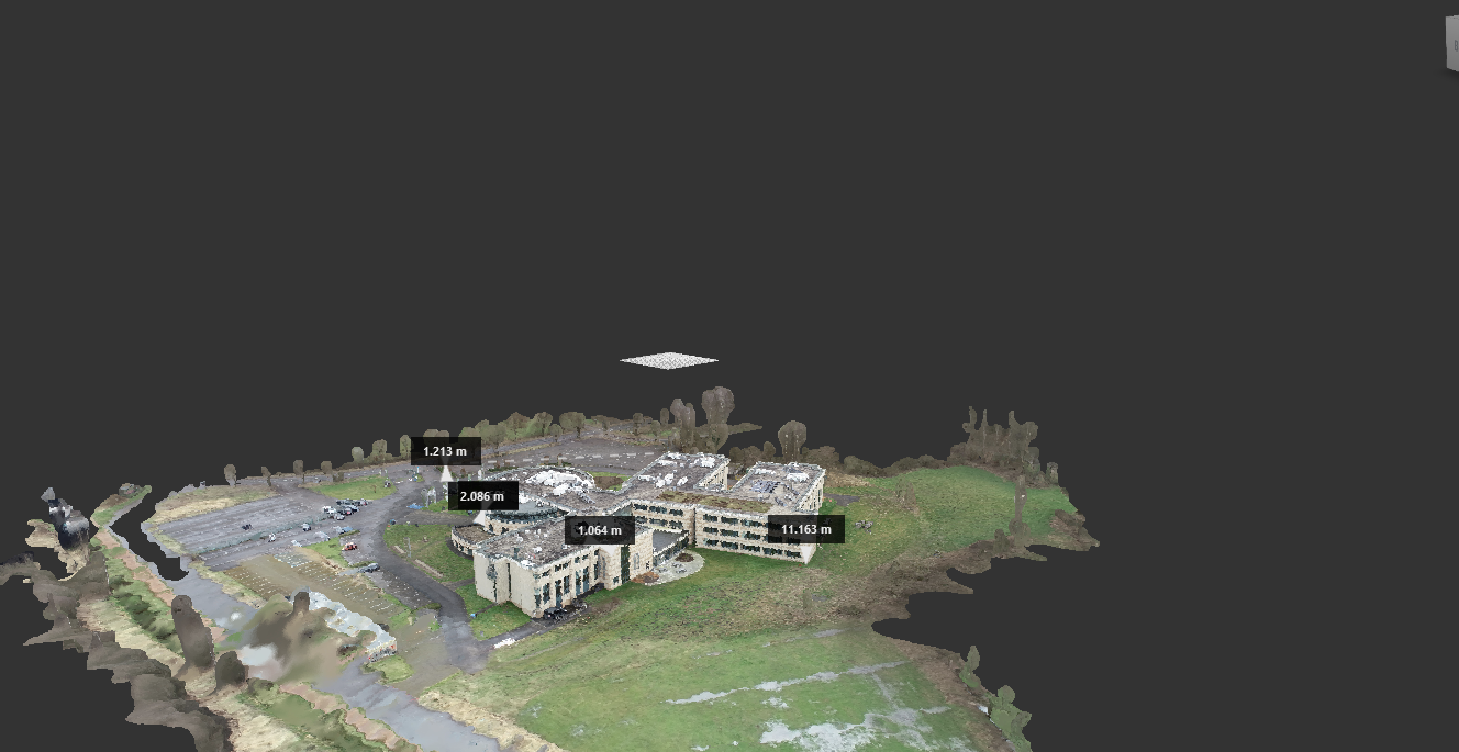
Measurement
To deploy the point cloud model to perform accurate measurements, both (professional point) cloud software and Recap can be used to perform measurements. The latter has more advanced features with functional guides and there is now the ability to measure the diameter of pipes and/or ducts using the ‘Pipe snap’ function.
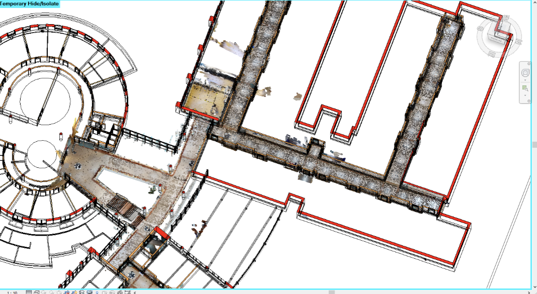
Besides frequent scans taken with the scanners on a tripod, an additional path of the PXL – Campus Diepenbeek corridor system was chosen. The entire corridor system was scanned and generated into a geometric model or point cloud. This allows this scan to be used together with the point cloud generated from the drone scan. The point cloud was loaded into the project and this allowed us to check if it matched the drone scan. The distance between where the scans were taken proved decisive in this case to minimise the margins.
3D Models
When the point cloud is generated, multiple applications are possible, such as creating a 3D model with textures, so that it can be used for a variety of applications that work with 3D models and/or are further editable such as, for example, Blender, Unity3D, 3ds Max and Maya. Once the data from the scans has been made available to the end user, there lies the possibility of generating a 3D model such as, for example, an FBX or OBJ file.

Augmented Reality
Applications for the use of 3D models are increasing at an accelerated pace, and using this model greatly expands the possibilities for their deployment. Applications for mobile devices such as tablets and smartphones can effectively work with these 3D models to display them in a user-friendly manner. This allows the 3D model to be easily enriched with data or offers the ability to navigate through the environment/model. This is fully applicable to the increasing demand for immersive techniques such as Augmented and Virtual Reality.
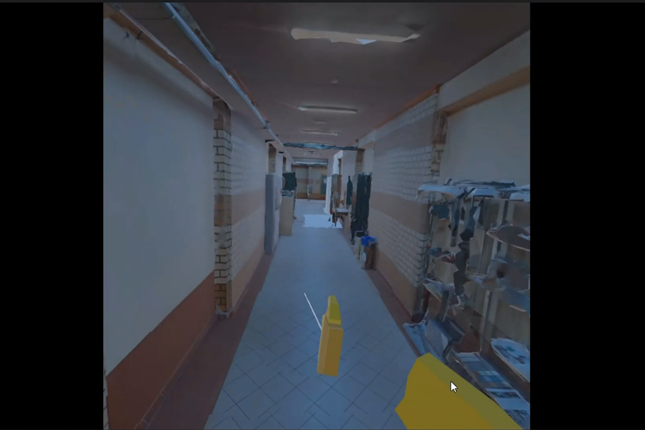
Virtual Reality
The scan created was then used in a self-developed Virtual Reality application using Unity 3D to navigate through the environment using Virtual Reality glasses, supplemented by interactive actions such as being able to move objects. Augmented Reality glasses were used to view the drone scan intently. Applications are also available to take direct measurements via Augmented Reality and to collaborate online in order to view and/or inspect the model with multiple stakeholders online.
How can photogrammetry technology be used to efficiently, effectively and cost-effectively make accurate geometric measurement available for processes in the construction industry?
From literature review, questionnaires and interviews, it emerged during this project that the demand for accurate geometric measurement is high, but at the same time cost efficiency is a very important aspect. This includes the complexity and labour intensity for performing accurate measurements. The results from this project were carried out in a multidisciplinary and user-accessible way, making them widely accessible to end users and within future projects within PXL University College. The desire to be able to use available devices such as tablets and smartphones was answered and became an important part of the implementation.
In addition, the combination with professional software is essential to achieve accurate measurements, which is reflected in the investments required for this. Purchasing fixed scanners, drones and software are a hefty investment cost. If the end user already owns the latest high-end tablets and smartphones in their organisation, this can be seen as an advantage over cost efficiency.